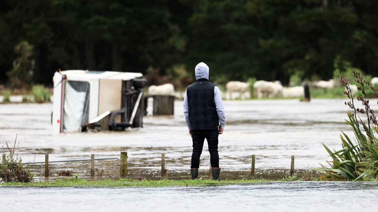
New research led by Earth Sciences New Zealand with the University of Waikato’s Associate Professor Silvia Serrao-Neumann and Professor Iain White reveals that more than 750,000 New Zealanders live in locations exposed to flooding from one-in-100-year rainfall flooding events. And this number could increase to more than 900,000 with a further 3 degrees of warming due to climate change.
Around $235 billion worth of buildings across the country are exposed, which could rise to $288 billion if there is 3 degrees of additional warming.
26,800 kms of the nation's roads, 14,100 kms of stormwater pipelines and 21% of national grid sites (e.g. substations) are also exposed to flooding under New Zealand’s current climate. This could rise to 30,800 kms, 15,400 kms and 29%, respectively, with 3 degrees of warming.
“Our country’s flood risk is increasing, and not just in places where we can remember floods occurring. This is partly due to climate change – we know rainfall intensity is increasing across Aotearoa, with more rain falling in shorter periods. Rapid urban intensification is another contributing factor,” says Dr Emily Lane, the programme leader and principal hazards scientist at Earth Sciences NZ.

Professor Iain White
The research revealed significant regional variations in exposure, ranging from 8% of people in Taranaki exposed to one-in-100-year rainfall events under the current climate to 34% on the West Coast.
The findings come from the culmination of a five-year research programme looking at flood risk across Aotearoa New Zealand. The programme involved wide-ranging collaboration with other research organisations, universities, councils, central government agencies and industry.
A major output of the project is the country’s first nationally consistent flood hazard viewer. The researchers applied a consistent method for flood modelling from 1% annual exceedance probability (AEP) rainfall to create new maps for 256 flood plains around the country. It is the first time rainfall flood maps covering different regions of the country can be viewed in a single online tool. The mapping workflow was carried out for New Zealand’s current climate and then repeated for the three climate change scenarios (+1, +2 and +3 degrees of additional warming), compared with the current climate.
An important part of this research programme, led by Professor White and Associate Professor Serrao-Neumann, involved bringing together river managers, iwi, government agencies, financial institutions and stakeholders. This enabled the research team to ensure that programme outputs would be useable and useful, to explore adaptation options under changing climate conditions, and to design new ways to make decisions, taking into account climate and socio-economic projections.
“Flood risk management is handled differently in different regions, and, to date, there’s no consistent way to assess current flood risk or how this might change under climate change. Local and regional governments also vary in how they manage and reduce these risks. Our research helps to address this by providing a consistent and coordinated approach to understanding, measuring, and communicating flood risk at a national-level,” says Associate Professor Serrao-Neumann.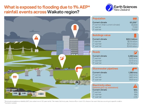
“Having consistent information is crucial for others to act to manage their own risk – from business to communities to infrastructure providers. This tool helps enable consistent processes for modelling and provides the foundation on which to build national-scale resilience. Providing certainty to decision makers will help avoid passing liabilities to current and future generations,” says Professor White.
Dr Sam Dean, principal climate scientist at Earth Sciences NZ, says, “Increasing extreme rainfall due to climate change is one of the biggest and most impactful hazards faced by New Zealand. The building of our towns and flood defences have been shaped by historical floods that are no longer a reliable guide to the future.
“Predicting how flood risk is going to change is important to ensure we can protect people and places that we value in the most cost-effective way.
“Our new flood hazard viewer provides a clearer view across the country of which communities are at greatest risk from flooding, now and as the climate changes. The tool can be used to support risk assessments and adaptation investment decisions,” says Dr Dean.
The new flood hazard viewer provides a bird’s-eye view (to street level) to identify areas most at risk – supporting national policy development and risk assessment and helping to make a national case for prioritisation and investment planning. It also fills gaps for locations that don’t already have this information. As the first nationally consistent view of flood hazard available to New Zealanders, it is a significant first step towards a national flood map that will be able to provide property-level information about risk.
Dr Lane says Earth Sciences NZ’s tool is complementary to localised maps already developed by many of New Zealand’s regional and unitary councils.
“It does not replace them. Local and regional flood models can provide the precision needed to understand property-level risk and to design infrastructure,” she says.

Associate Professor Silvia Serrao-Neumann
Graeme Campbell, River Management Advisor for Te Uru Kahika – Regional and Unitary Councils Aotearoa, has been involved throughout the project.
"In New Zealand, detailed local flood hazard maps are made available by local government agencies and provide essential information for local decision-making. Regional and unitary councils will continue to make these maps available, and the new national tool produced by Earth Sciences NZ does not replace these local flood hazard maps.
“Instead, it adds value by providing information where there are currently gaps and improving the comparability of flood hazard assessments nationwide. Recognising the importance of local flood knowledge and expertise, Earth Sciences NZ has engaged closely with regional council river managers and scientists for the duration of this five-year research program," he says
The five-year research programme, titled Mā te haumaru o ngā puna wai o Rākaihautū ka ora mō ake tonu, also included a detailed look at complex social interactions for communities affected by flooding, including with programme partners Wairewa Rūnanga.
The research was funded by the Ministry for Business, Innovation and Employment’s Endeavour Fund.
The new GIS viewer for flood hazard across Aotearoa New Zealand (1% AEP rainfall events) is available at: https://niwa.maps.arcgis.com/apps/dashboards/8c1db2b8e37841f29a57a38675388897
Further background to the project, including the other parts of the programme and a list of outputs to date: https://niwa.co.nz/hazards/ma-te-haumaru-o-nga-puna-wai-o-rakaihautu-ka-ora-mo-ake-tonu